Maritime and aerial border of Graecia: Difference between revisions
No edit summary |
|||
| Line 8: | Line 8: | ||
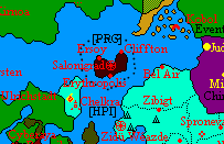
The border has an egg-like shape; speaking without details, it can be measured with the help of the coastal cities of Graecia. It can be reached at 598km. from Ersoy, 250km. from Cliffton, and 300km. from Erythropolis. Unite theese 3 points, and the border is made. | The border has an egg-like shape; speaking without details, it can be measured with the help of the coastal cities of Graecia. It can be reached at 598km. from Ersoy, 250km. from Cliffton, and 300km. from Erythropolis. Unite theese 3 points, and the border is made. | ||
With theese taken in mind, and not forgetting the recent expansions made by Graecia's neighbors, Graecia is surrounded by the territoriall waters of two nations: [[The Hexarchy]] in the northwest, north and northeast, the [[Haifo-Pallisican Imperial Trade Union]] in the east, southeast, south and southwest. A four-nation point is, as such, created on the western border, between the Hexarchy, Graecia, the Imperial Trade Union and the Green (unclaimed territories). | With theese taken in mind, and not forgetting the recent expansions made by Graecia's neighbors, Graecia is surrounded by the territoriall waters of two nations: [[The Hexarchy]] in the northwest, north and northeast, the [[Haifo-Pallisican Imperial Trade Union]] in the east, southeast, south and southwest. A four-nation point is, as such, created on the western border, between the Hexarchy, Graecia, the Imperial Trade Union and the Green (unclaimed territories). | ||
The People's Repiblic of Graecia and the [[Alduria-Wechua|Aldurian-Wechuan Federation]] are separated by about 300-400km. of territoriall waters of the Hexarchy and the Imperial Trae Union. | The People's Repiblic of Graecia and the [[Alduria-Wechua|Aldurian-Wechuan Federation]] are separated by about 300-400km. of territoriall waters of the Hexarchy and the Imperial Trae Union. The same happens with some controlled areas of [[Phinbella]], which are separated from Graecia by the Imperial Trade Union's coastal area. | ||
The border is demarcated by buoys on it's entire lenght. The buoys are Graecian-made, and fly two flags: The [[Flag of Graecia]] on the Graecian side, and the flag of the bordering nation, from their side. When there is heavy rain, a patroll boat removes the textile-made flags; so, to avoid confusion in theese cases, the flags are also painted on each side of the buoy. | |||
Revision as of 22:01, 4 September 2020

|
This article or section is a work in progress. The information below may be incomplete, outdated, or subject to change. |
Currently, the land claims of the People's Republic of Graecia are limited to one relatively small island surrounded by the Keltian continent, and has no land borders. However, the State has defined an area which is the claimed Maritime and Aerial border of the People's Republic of Graecia. Graecia has not signed a number of treaties that allegedly help to define a nations's territorial waters, so their claims to not come in compliance with them; however, as it is not a signatory to such treaties, and it has never received any complain about this, Graecia is unlikely to change the border (except if it expands, which was something likely untill recent events).
Details

The border has an egg-like shape; speaking without details, it can be measured with the help of the coastal cities of Graecia. It can be reached at 598km. from Ersoy, 250km. from Cliffton, and 300km. from Erythropolis. Unite theese 3 points, and the border is made. With theese taken in mind, and not forgetting the recent expansions made by Graecia's neighbors, Graecia is surrounded by the territoriall waters of two nations: The Hexarchy in the northwest, north and northeast, the Haifo-Pallisican Imperial Trade Union in the east, southeast, south and southwest. A four-nation point is, as such, created on the western border, between the Hexarchy, Graecia, the Imperial Trade Union and the Green (unclaimed territories). The People's Repiblic of Graecia and the Aldurian-Wechuan Federation are separated by about 300-400km. of territoriall waters of the Hexarchy and the Imperial Trae Union. The same happens with some controlled areas of Phinbella, which are separated from Graecia by the Imperial Trade Union's coastal area. The border is demarcated by buoys on it's entire lenght. The buoys are Graecian-made, and fly two flags: The Flag of Graecia on the Graecian side, and the flag of the bordering nation, from their side. When there is heavy rain, a patroll boat removes the textile-made flags; so, to avoid confusion in theese cases, the flags are also painted on each side of the buoy.