Cibola: Difference between revisions
No edit summary |
No edit summary |
||
| Line 14: | Line 14: | ||
==Origins and Etymology== | ==Origins and Etymology== | ||
Cibola was added, along with several smaller islands, in Series Seven as part of | Cibola was added, along with several smaller islands, in Series Seven as part of Augustin Dei Barbone's plan to expand available land area. Its existence is controversial, but because of its importance to the many countries inhabiting it, it was never seriously in danger of being removed like some other islands. The name Cibola comes from the legends of Seven Cities of Gold founded by Spanish bishops in Western North America, and other areas around the continent are also named after legendary American riches, for example the island of El Dorado. | ||
==Geography== | ==Geography== | ||
Revision as of 13:30, 19 June 2020

| |
|
| |
| Total Area: | 11,384,158.59 km² |
| Area of major landmass: | {{{area_landmass}}} km² |
| Population: | 120 |
| Date founded: | {{{date_founded}}} |
| Countries: | 6 |
| Dependencies: | 0 |
| Languages: | English, Shirithian, Syriac, Dutch, German, Sdrawkcab |
| Largest Cities: | Geneva Matbaa Vladishopnuu |
Cibola is a continent on Micras.
Origins and Etymology
Cibola was added, along with several smaller islands, in Series Seven as part of Augustin Dei Barbone's plan to expand available land area. Its existence is controversial, but because of its importance to the many countries inhabiting it, it was never seriously in danger of being removed like some other islands. The name Cibola comes from the legends of Seven Cities of Gold founded by Spanish bishops in Western North America, and other areas around the continent are also named after legendary American riches, for example the island of El Dorado.
Geography
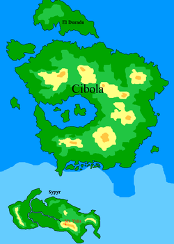
Cibola has a strange shape best interpreted as half of a crater. The coast is roughly circular, but briefly broken in the west by a narrow straight leading to a large inland bay with three islands inside. In the center, surrounding the bay, are a circular range of mountains looking like a crater rim, again broken to the west. The area outside these mountains slopes gradually down to a ring of plains that form the continent's most habitable area, especially in its easternmost portions. The north of Cibola is partly desert, and the south is partly tundra. Cibola's tallest peak is Mt. Julia, 4856 m high. True to its name, the island is punctuated by seven mountains.
Recent tectonic studies have shown that Cibola was once part of a greater Pan-Micran supercontinent that was connected in the east to Tapfer and in the west to Corum, with Mar Sara and other islands breaking off during the separation process. The Flying Islands, having been placed in the area by artificial means, were not part of the supercontinent. As Cibola shifted westward, the island apparently crossed a chasm left by the dragging action of previous continental shift which caused the central areas of the island to collapse, forming the current crater-like geography. Once in this chasm, the collapsed material formed a blockage that prevented the island from shifting further, except for El Dorado, which experienced the remaining momentum sheared off to the north, and Sypyr, which sheared southward.
History
As soon as Cibola was created, the east was claimed by a few countries including San Martin, Alexandria, and Storjord, of which the former two survived and became somewhat influential. The west, around the bay and islands, was originally the domain of a few Germanic-themed countries like Treisenberg. Of these, Alexandria long outlasted the other, and dominates the continent today. Matbaa also had a large presence on Cibola for several years. Today, Cibola includes Alexandria, Heimat, as well as colonies of Stormark, Batavia, and Craiteland.