Ramez (province): Difference between revisions
From MicrasWiki
Jump to navigationJump to search
No edit summary |
mNo edit summary |
||
| Line 8: | Line 8: | ||
|} | |} | ||
|- | |- | ||
|colspan=2 align=center | [[Image:Ramez in Gerenia.png|250px|Location of Ramez|frameless]] | |colspan=2 align=center | [[Image:Ramez in Gerenia.png|250px|Location of Ramez|frameless]]<br>Location of Ramez | ||
|-class="mergedtoprow" | |-class="mergedtoprow" | ||
|align=left |'''Established''' ||align=left | 8 July 2012 | |align=left |'''Established''' ||align=left | 8 July 2012 | ||
| Line 24: | Line 24: | ||
|align=left |'''Area''' ||align=left | 5,632 km² | |align=left |'''Area''' ||align=left | 5,632 km² | ||
|-class="mergedrow" | |-class="mergedrow" | ||
|align=left | - Ranked ||align=left | | |align=left | - Ranked ||align=left | 9th | ||
|-class="mergedtoprow" | |-class="mergedtoprow" | ||
|align=left |'''Population''' ||align=left | 471,497 (2017) | |align=left |'''Population''' ||align=left | 471,497 (2017) | ||
Revision as of 16:47, 22 July 2017
| Ramez Province Proziu Ramezes (gr) | |||
| |||
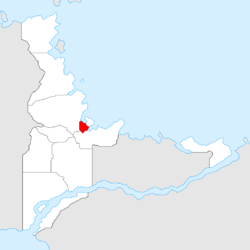
 Location of Ramez | |||
| Established | 8 July 2012 | ||
| Capital | Ramez | ||
| Largest cities | Ramez, Salavul, San Martín, San Andrés | ||
| Demonym | Ramezian | ||
| - Adjective | Ramezian | ||
| Governor | Julian Albets (IPG) | ||
| Area | 5,632 km² | ||
| - Ranked | 9th | ||
| Population | 471,497 (2017) | ||
| - Ranked | 6th | ||
| Density | 83.72/km² | ||
| Abbreviation | RZ | ||
Ramez is a Gerenian province. It is bordered by Barzat to the south, Maremedres to the west, and Erstveda to the northeast, at both its north and east lies the Northern Sea.
Ramez is one of the least extensive, but the second most densely populated of the nation. Approximately two thirds of its population lives in the north and the east, where the capital, Ramez, and the biggest cities, are located. The west of Ramez features a mix of small villages and rural areas.
Originally depending on agriculture and trade, the entire province of Ramez developed alongside nearby Port Elerat, and became a major industry centre.
See also
| |||||

