Burwood Forest: Difference between revisions
No edit summary |
No edit summary |
||
| (One intermediate revision by the same user not shown) | |||
| Line 23: | Line 23: | ||
'''Burwood Forest''' is a large mixed evergreen and deciduous forest stretching across parts of [[Moorland]] and, previously, parts of [[Ostland]] (now [[Burwood]]) in northeast [[Keltia]]. The forest has some of the most sizable concentrations of old growth forest in the area and was standing when the first settlers from [[Nova England]] arrived in the area and named it Burwood. The forest covers a large area of over nine-thousand square miles stretching from just north of [[Fort Hunter]] and north to the outskirts of Copthorne and St Joseph's. Although initially avoided by developers for its rough terrain, encroachment by industrialization was eventually halted by Nova England and the forests were preserved. Some areas were set aside for sustainable timber harvesting while others were dedicated as permanently protected parks with many hiking trails, campgrounds and other public amenities. Drought conditions in 1727 and the carelessness of campers were said to blame for the [[Burwood Wildfires]] that now threaten much of the forest. The fires were extinguished by late 1728, but the loss of forest was estimated to be around 10,000 acres. Conservation efforts are underway to replant the forests and provide safeguards against future fires, such as building firebreaks and conducting regular controlled burns. | '''Burwood Forest''' is a large mixed evergreen and deciduous forest stretching across parts of [[Moorland]] and, previously, parts of [[Ostland]] (now [[Burwood]]) in northeast [[Keltia]]. The forest has some of the most sizable concentrations of old growth forest in the area and was standing when the first settlers from [[Nova England]] arrived in the area and named it Burwood. The forest covers a large area of over nine-thousand square miles stretching from just north of [[Fort Hunter]] and north to the outskirts of Copthorne and St Joseph's. Although initially avoided by developers for its rough terrain, encroachment by industrialization was eventually halted by Nova England and the forests were preserved. Some areas were set aside for sustainable timber harvesting while others were dedicated as permanently protected parks with many hiking trails, campgrounds and other public amenities. Drought conditions in 1727 and the carelessness of campers were said to blame for the [[Burwood Wildfires]] that now threaten much of the forest. The fires were extinguished by late 1728, but the loss of forest was estimated to be around 10,000 acres. Conservation efforts are underway to replant the forests and provide safeguards against future fires, such as building firebreaks and conducting regular controlled burns. | ||
In 1729 the Witan approved a measure designating most of Burwood as conservation forest. The Burwood Parks Commission was created to oversee management of the parks, and the lands were divided into five separate park areas under the one umbrella agency. | In 1729 the Witan approved a measure designating most of Burwood as conservation forest. The Burwood Parks Commission was created to oversee management of the parks, and the lands were divided into five separate park areas under the one umbrella agency. Most of the parks are limited to seasonal recreational use, such as hiking, fishing and camping. Several locations offer RV parks for year-round camping, but these are limited in size and scope as to keep human impacts to a minimum. Western Woods Park is completely off limits to the public and is a planted forest used exclusively for sustainable timber harvesting, mostly groves of planted [[Moor Pine]]. One modern addition is Burwood ATV Park, which is unique in that it allows the use of off-road all-terrain-vehicles on designated trails. The thought process behind this is to concentrate the adverse effects of this recreational sport in one area so as to isolate environmental damage. Trails here are open to four-wheelers and dirt bikes in the summer, snowmobiles in the winter, and some seasonal hunting. Use of off-road vehicles is extremely prohibited in all other parks, with violators risking heavy fines or license revocation. | ||
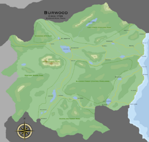
[[File:Burwood-forest-map.png|left|thumb|Burwood Royal Parks, circa 1729]] | [[File:Burwood-forest-map.png|left|thumb|Burwood Royal Parks, circa 1729]] | ||
| Line 32: | Line 32: | ||
| Burwood Forest - Central Parklands || Limited use: hiking, camping | | Burwood Forest - Central Parklands || Limited use: hiking, camping | ||
|- | |- | ||
| Loch Forth | | Loch Forth Highland Park || Limited use: hiking, camping, fishing | ||
|- | |- | ||
| Burwood ATV Park || Exclusive use: ATV usage allowed, seasonal hunting | | Burwood ATV Park || Exclusive use: ATV usage allowed, seasonal hunting | ||
Latest revision as of 13:53, 6 February 2024
 Evergreen and deciduous forest. | |
| General information | |
|---|---|
| Location | Moorland |
| Area | 9,112 sq mi |
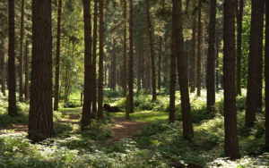
Burwood Forest is a large mixed evergreen and deciduous forest stretching across parts of Moorland and, previously, parts of Ostland (now Burwood) in northeast Keltia. The forest has some of the most sizable concentrations of old growth forest in the area and was standing when the first settlers from Nova England arrived in the area and named it Burwood. The forest covers a large area of over nine-thousand square miles stretching from just north of Fort Hunter and north to the outskirts of Copthorne and St Joseph's. Although initially avoided by developers for its rough terrain, encroachment by industrialization was eventually halted by Nova England and the forests were preserved. Some areas were set aside for sustainable timber harvesting while others were dedicated as permanently protected parks with many hiking trails, campgrounds and other public amenities. Drought conditions in 1727 and the carelessness of campers were said to blame for the Burwood Wildfires that now threaten much of the forest. The fires were extinguished by late 1728, but the loss of forest was estimated to be around 10,000 acres. Conservation efforts are underway to replant the forests and provide safeguards against future fires, such as building firebreaks and conducting regular controlled burns.
In 1729 the Witan approved a measure designating most of Burwood as conservation forest. The Burwood Parks Commission was created to oversee management of the parks, and the lands were divided into five separate park areas under the one umbrella agency. Most of the parks are limited to seasonal recreational use, such as hiking, fishing and camping. Several locations offer RV parks for year-round camping, but these are limited in size and scope as to keep human impacts to a minimum. Western Woods Park is completely off limits to the public and is a planted forest used exclusively for sustainable timber harvesting, mostly groves of planted Moor Pine. One modern addition is Burwood ATV Park, which is unique in that it allows the use of off-road all-terrain-vehicles on designated trails. The thought process behind this is to concentrate the adverse effects of this recreational sport in one area so as to isolate environmental damage. Trails here are open to four-wheelers and dirt bikes in the summer, snowmobiles in the winter, and some seasonal hunting. Use of off-road vehicles is extremely prohibited in all other parks, with violators risking heavy fines or license revocation.
| Park Name | Amenities |
|---|---|
| Burwood Forest - Central Parklands | Limited use: hiking, camping |
| Loch Forth Highland Park | Limited use: hiking, camping, fishing |
| Burwood ATV Park | Exclusive use: ATV usage allowed, seasonal hunting |
| Western Woods Park | Exclusive use: Sustainable timber forest |
| Huntsland Forest Park | Limited use: hiking, camping, hunting |
