Great Aerlan Highway: Difference between revisions
No edit summary |
mNo edit summary |
||
| (4 intermediate revisions by the same user not shown) | |||
| Line 1: | Line 1: | ||
{{Aerla article}} | {{Aerla article}} | ||
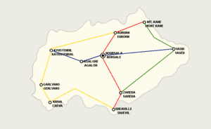
[[File:Aerla highways.png|300px|thumb|right| | [[File:Aerla highways.png|300px|thumb|right|The G.A.H. is made of 4 constituent highways. These are:<br>{{Color box|#FF0000}}H-1 (Sheaville to Mt. Kane): began {{AN|1715}}, completed {{AN|1721}}.<br>{{Color box|#00137F}}H-2 ([[Kyustendil]] to [[Yasid]]): began {{AN|1717}}, completed {{AN|1723}}.<br>{{Color box|#267F00}}H-3 (Mt. Kane to Zareda): began {{AN|1718}}, completed {{AN|1724}}<br>{{Color box|#FFD800}}H-4 (Auburn to Sheaville, "Ranentsian Highway"): began {{AN|1719}}, finished {{AN|1728}}]] | ||
The '''{{PAGENAME}}''' ([[Aerlan Commonspeak|Commonspeak]]: Gröt Ayrlen | The '''{{PAGENAME}}''' ([[Aerlan Commonspeak|Commonspeak]]: Gröt Ayrlen Ætostras) is the name given to a transportation [[wikipedia:megaproject|megaproject]] that links all major cities in [[Aerla]] with each other via highway. The first phase of construction began in {{AN|1715}}, with the entire system being completed by early {{AN|1728}}. | ||
==History== | ==History== | ||
| Line 10: | Line 10: | ||
The lack of continuous land routes for transportation has plagued the Central [[Keltia]]n valleys for centuries. Upon Aerla's inception in {{AN|1709}}. the longest continuous "road" was a dirt trackway from [[Zareda]] to [[Noursala]]. The government soon diverted large portions of their budget to modernizing infrastructure (most of this going towards the [[Harriston-Agalore Rail Corridor]]. completed in early {{AN|1718}}). The lack of established highway systems was accredited as a reason the response to the [[Insurgency in Ancora]] was so delayed, as troops had to be deployed via winding dirt roads and small narrow-gauge railroads. | The lack of continuous land routes for transportation has plagued the Central [[Keltia]]n valleys for centuries. Upon Aerla's inception in {{AN|1709}}. the longest continuous "road" was a dirt trackway from [[Zareda]] to [[Noursala]]. The government soon diverted large portions of their budget to modernizing infrastructure (most of this going towards the [[Harriston-Agalore Rail Corridor]]. completed in early {{AN|1718}}). The lack of established highway systems was accredited as a reason the response to the [[Insurgency in Ancora]] was so delayed, as troops had to be deployed via winding dirt roads and small narrow-gauge railroads. | ||
The [[National Assembly of Aerla|National Assembly]] approved a bill in {{AN|1715}} to begin construction on a "Great Aerlan Highway" that would link all major population centers together. The bill was approved with a majority vote, and the plan was signed by [[Henry Cassian]] the following day. The first phase of construction began with a ceremonial christening of a excavator in Noursala by Transportation Minister Maurice Bridgeman. | The [[National Assembly of Aerla|National Assembly]] approved a bill in {{AN|1715}} to begin construction on a "Great Aerlan Highway" that would link all major population centers together. The bill was approved with a majority vote, and the plan was signed by [[Henry Cassian]] the following day. The first phase of construction began with a ceremonial christening of a excavator in Noursala by Transportation Minister, the aptly named Maurice Bridgeman. | ||
===Construction=== | ===Construction=== | ||
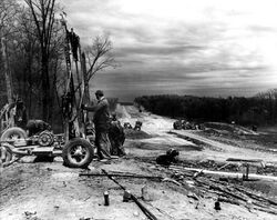
Groups of workers began clearing right of ways away from each of the terminuses. Heavy logging equipment was provided via government funds to help clear vast swathes of forest that lie between each cities. Tunnels through major hills were cleared by either mining crews or explosives, if appropriate. | Groups of workers began clearing right of ways away from each of the terminuses. Heavy logging equipment was provided via government funds to help clear vast swathes of forest that lie between each cities. Tunnels through major hills were cleared by either mining crews or explosives, if appropriate. Land for the highway was mostly bought from landowners, although some use of eminent domain was recorded closer to the cities. Landowners who were affected by the highways were compensated given heavy monetary compensation for the acquisition for their land. Steel bridges were installed in order to connect communities divided by the highway. | ||
==Regulations== | |||
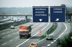
[[File:Aerla highway.png|thumb|rights|250px|A stretch of highway H-2 near the town of Syrenea.]] | |||
The legislation authorizing the construction of the highway also authorized the creation of a regulations board, known as the ''Highway Safety and Regulatory Council'' (Commonspeak: Austras Säfte en Reglasön Majlëß). This council has oversights on any safety, legal, and other regulations that govern the highway. | |||
===Speed Limits=== | |||
It was decided early on that the speed limit for sections of the highway would be decided on the [[Subdivisions of Aerla|municipality]]-level of government. For the most part, the speed limit is set to 80 kph through cities, and 120 kph through rural areas. One notable exception to this rule is through the the Municipality of Wildwood, where there is no speed limit on the highway while it crosses into it's municipal boundaries. However, when crossing into any of the neighboring municipalities the speed limit becomes 120 kph once again. This issue has caused multiple traffic accidents as drivers, wary of traffic stops, will suddenly slam their breaks when crossing municipal lines. | |||
===Lanes=== | |||
The entire highway system is composed of 4 lanes. The Highway Safety and Regulatory Council dictates that the far right lane (Lane 1) is reserved for trucks and other slow-moving large vehicles over 3 tonnes, as well as cars who will exit the highway on an oncoming ramp. Lane 2 is reserved for slower-moving cars, Lane 3 for fast-moving cars, and Lane 4 for carpools. | |||
[[Category:Roads]] [[Category:Transportation]] | [[Category:Roads]] [[Category:Transportation]] | ||
Latest revision as of 17:11, 3 June 2024

H-1 (Sheaville to Mt. Kane): began 1715 AN, completed 1721 AN.
H-2 (Kyustendil to Yasid): began 1717 AN, completed 1723 AN.
H-3 (Mt. Kane to Zareda): began 1718 AN, completed 1724 AN
H-4 (Auburn to Sheaville, "Ranentsian Highway"): began 1719 AN, finished 1728 AN
The Great Aerlan Highway (Commonspeak: Gröt Ayrlen Ætostras) is the name given to a transportation megaproject that links all major cities in Aerla with each other via highway. The first phase of construction began in 1715 AN, with the entire system being completed by early 1728 AN.
History
Background
The lack of continuous land routes for transportation has plagued the Central Keltian valleys for centuries. Upon Aerla's inception in 1709 AN. the longest continuous "road" was a dirt trackway from Zareda to Noursala. The government soon diverted large portions of their budget to modernizing infrastructure (most of this going towards the Harriston-Agalore Rail Corridor. completed in early 1718 AN). The lack of established highway systems was accredited as a reason the response to the Insurgency in Ancora was so delayed, as troops had to be deployed via winding dirt roads and small narrow-gauge railroads.
The National Assembly approved a bill in 1715 AN to begin construction on a "Great Aerlan Highway" that would link all major population centers together. The bill was approved with a majority vote, and the plan was signed by Henry Cassian the following day. The first phase of construction began with a ceremonial christening of a excavator in Noursala by Transportation Minister, the aptly named Maurice Bridgeman.
Construction
Groups of workers began clearing right of ways away from each of the terminuses. Heavy logging equipment was provided via government funds to help clear vast swathes of forest that lie between each cities. Tunnels through major hills were cleared by either mining crews or explosives, if appropriate. Land for the highway was mostly bought from landowners, although some use of eminent domain was recorded closer to the cities. Landowners who were affected by the highways were compensated given heavy monetary compensation for the acquisition for their land. Steel bridges were installed in order to connect communities divided by the highway.
Regulations
The legislation authorizing the construction of the highway also authorized the creation of a regulations board, known as the Highway Safety and Regulatory Council (Commonspeak: Austras Säfte en Reglasön Majlëß). This council has oversights on any safety, legal, and other regulations that govern the highway.
Speed Limits
It was decided early on that the speed limit for sections of the highway would be decided on the municipality-level of government. For the most part, the speed limit is set to 80 kph through cities, and 120 kph through rural areas. One notable exception to this rule is through the the Municipality of Wildwood, where there is no speed limit on the highway while it crosses into it's municipal boundaries. However, when crossing into any of the neighboring municipalities the speed limit becomes 120 kph once again. This issue has caused multiple traffic accidents as drivers, wary of traffic stops, will suddenly slam their breaks when crossing municipal lines.
Lanes
The entire highway system is composed of 4 lanes. The Highway Safety and Regulatory Council dictates that the far right lane (Lane 1) is reserved for trucks and other slow-moving large vehicles over 3 tonnes, as well as cars who will exit the highway on an oncoming ramp. Lane 2 is reserved for slower-moving cars, Lane 3 for fast-moving cars, and Lane 4 for carpools.

