Matamoros: Difference between revisions
No edit summary |
mNo edit summary |
||
| (2 intermediate revisions by the same user not shown) | |||
| Line 1: | Line 1: | ||
{{Infobox settlement | {{Infobox settlement | ||
| name = Matamoros State | | name = Matamoros State | ||
| Line 46: | Line 45: | ||
==History== | ==History== | ||
The land that now forms Matamoros state has a long history of settlement, trade and the harvesting of natural resources. River traders from [[Bosworth]] frequently set up encampments in the area when transiting along the Rio Rojo to reach the Blore Heath trading port. These traders taught [[Britannic Istvanistani]] to the local population, and the language is still widespread as a second language in the state. This bilingualism meant that many residents of Matamoros acted as interpreters when later settlers from [[Gran Verionia]] intermingled with mercenaries and settlers from [[Nova England]]. | |||
Although Matamoros shares a border with Granaditas, the state avoided becoming heavily involved in the [[Anahuaco#Civil_war|civil war]] and has largely avoided the insurgency that continues in the neighbouring state. With a combination of rainforest and coastal plain ecosystems, Matamoros has developed a thriving agricultural industry, while also benefiting from eco-tourism. | |||
==Government== | |||
In common with all the states of Anahuaco, Matamoros directly elects a state legislature using a proportional voting system, with universal suffrage for citizens over the age of 16. | |||
The head of the state government is a governor appointed by the Emperor. The current Governor of Matamoros is Jorge Carlos Dosal. | |||
The state is the birthday and stronghold of the Partido Liberal Anahuacano (Anahuacan Liberal Party), which has dominated the state's legislature since the foundation of the empire. As a result, Matamoros is widely considered to be one of the most progressive and tolerant parts of Anahuaco. | |||
==Geography== | |||
The geography of Matamoros state can broadly be divided into two distinct zones- the tropical north, and the mild, coastal climate of the south. Dense rainforest dominates the majority of the state, diminishing only in the east where the increased altitudes of the Sierra del Sur mountain range make the climate unsuitable. | |||
Over a period of time, deforestation has created a coastal strip of productive agricultural land, and lands to the east of the Rio Rojo have also been cleared in some places. Despite this, much of the rainforest remains in pristine condition. | |||
The state capital, Hidalgo, sits on the southern coast of the state. | |||
[[Category:Anahuaco]] | [[Category:Anahuaco]] | ||
Latest revision as of 13:47, 15 April 2022
| Matamoros State Estado de Matamoros |
|
|---|---|
| State of Anahuaco | |
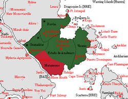
| Matamoros State (red) shown within Anahuaco (green) | |
| Nation | |
| Capital | Hidalgo |
| Population | |
| • Total | ~10 million |
Matamoros is the southernmost state of the Anahuaco. Bordered in the east by Estado de Anahuaco, to the north by Granaditas, to the south by the Great Eastern Ocean, and to the west by a river known locally as the Rio Rojo.
The state capital, Hidalgo, is the only state capital in the empire that sits on the coast, making it one of the most important ports in Anahuaco. The state's climate is a combination of coastal and tropical, with coastal plains giving way to dense jungle inland.
History
The land that now forms Matamoros state has a long history of settlement, trade and the harvesting of natural resources. River traders from Bosworth frequently set up encampments in the area when transiting along the Rio Rojo to reach the Blore Heath trading port. These traders taught Britannic Istvanistani to the local population, and the language is still widespread as a second language in the state. This bilingualism meant that many residents of Matamoros acted as interpreters when later settlers from Gran Verionia intermingled with mercenaries and settlers from Nova England.
Although Matamoros shares a border with Granaditas, the state avoided becoming heavily involved in the civil war and has largely avoided the insurgency that continues in the neighbouring state. With a combination of rainforest and coastal plain ecosystems, Matamoros has developed a thriving agricultural industry, while also benefiting from eco-tourism.
Government
In common with all the states of Anahuaco, Matamoros directly elects a state legislature using a proportional voting system, with universal suffrage for citizens over the age of 16.
The head of the state government is a governor appointed by the Emperor. The current Governor of Matamoros is Jorge Carlos Dosal.
The state is the birthday and stronghold of the Partido Liberal Anahuacano (Anahuacan Liberal Party), which has dominated the state's legislature since the foundation of the empire. As a result, Matamoros is widely considered to be one of the most progressive and tolerant parts of Anahuaco.
Geography
The geography of Matamoros state can broadly be divided into two distinct zones- the tropical north, and the mild, coastal climate of the south. Dense rainforest dominates the majority of the state, diminishing only in the east where the increased altitudes of the Sierra del Sur mountain range make the climate unsuitable.
Over a period of time, deforestation has created a coastal strip of productive agricultural land, and lands to the east of the Rio Rojo have also been cleared in some places. Despite this, much of the rainforest remains in pristine condition.
The state capital, Hidalgo, sits on the southern coast of the state.
