Cartography of Nouvelle Alexandrie: Difference between revisions
From MicrasWiki
Jump to navigationJump to search
| (6 intermediate revisions by 2 users not shown) | |||
| Line 1: | Line 1: | ||
{{Alduria-Wechua Article}}{{WIP}} | {{Alduria-Wechua Article}}{{WIP}} | ||
The '''cartography of | The '''cartography of Nouvelle Alexandrie''' is the history of geographical surveys and the creation of maps of the [[Nouvelle Alexandrie|Federation of Nouvelle Alexandrie]]. | ||
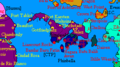
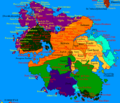
[[File:NAF_States_1693AN.png|right|thumbnail|350px|The cities and states of Nouvelle Alexandrie.]] | |||
==History== | ==History== | ||
| Line 10: | Line 11: | ||
===[[Bucolos et fils|Bucolos & Fils, Cartographer]]=== | ===[[Bucolos et fils|Bucolos & Fils, Cartographer]]=== | ||
<gallery> | <gallery> | ||
File: | File:NAF Alduria 1693AN.png|A map nothing the location of the Region of [[Alduria]] in the Federation. | ||
File: | File:NAF WechuaNation 1693AN.png|A map noting the location of the Region of the [[Wechua Nation]] in the Federation. | ||
File: | File:NAF Valencia 1693AN.png|A map noting the location of the Region of [[Valencia]] in the Federation. | ||
File: | File:NAF SouthLyrica 1693AN.png|A map noting the location of the Region of [[South Lyrica]] in the Federation. | ||
File: | File:NAF Santander 1693AN.png|A map noting the location of the Region of [[Santander]] in the Federation. | ||
File: | File:NAF Outremer 1693AN.png|A map noting the location of the unincorporated territories of [[Outremer]]. | ||
File: | File:NAF NorthLyrica 1693AN.png|A map noting the location of the Region of [[North Lyrica]] in the Federation. | ||
File: | File:NAF NewLuthoria 1693AN.png|A map noting the location of the Region of [[New Luthoria]] in the Federation. | ||
File: | File:NAF IslesOfCaputia 1693AN.png|A map noting the location of the Region of [[Isles of Caputia]] in the Federation. | ||
File: | File:NAF IslasDeLaLibertad 1693AN.png|A map noting the location of the Region of [[Islas de la Libertad]] in the Federation. | ||
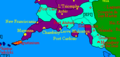
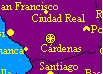
File:NAF FederalCapitalDistrict 1693AN.png|A map noting the location of the [[Cardenas|Federal Capital District]] in the Federation. | |||
</gallery> | </gallery> | ||
| Line 26: | Line 28: | ||
<gallery> | <gallery> | ||
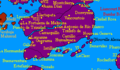
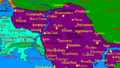
File:Santander1688AN.png|The Region of [[Santander]]. | File:Santander1688AN.png|The Region of [[Santander]]. | ||
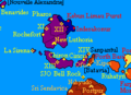
File: | File:South Lyrica.png|The Region of [[South Lyrica]]. | ||
File: | File:NorthLyrica2.PNG|The Region of [[North Lyrica]]. | ||
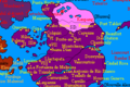
File:NewLuthoria1688AN.png|The Region of [[New Luthoria]]. | File:NewLuthoria1688AN.png|The Region of [[New Luthoria]]. | ||
File:IslesofCaputia1688AN.png|The Region of the [[Isles of Caputia]]. | File:IslesofCaputia1688AN.png|The Region of the [[Isles of Caputia]]. | ||
| Line 41: | Line 43: | ||
==Infrastructure== | ==Infrastructure== | ||
<gallery>File:Map8-12-20.png|[[Pan-Keltian Highway]]. | <gallery>File:Map8-12-20.png|[[Pan-Keltian Highway]]. | ||
File:ProposedTransEuranHighway.png|[[Pan-Euran Highway]]. | File:ProposedTransEuranHighway.png|[[Pan-Euran Highway]] proposal ({{AN|1691}}-{{AN|1693}}). | ||
File:Route2EuranHighway1694.png|[[Pan-Euran Highway]] proposal ({{AN|1694}}). | |||
File:CURRENT-ALDURIAN-HIGHWAYS.png|Aldurian highways, old map from {{AN|1673}}. | File:CURRENT-ALDURIAN-HIGHWAYS.png|Aldurian highways, old map from {{AN|1673}}. | ||
File:CURRENT-ALDURIAN-RAILWAYS.png|Aldurian railways, old map from {{AN|1673}}. | File:CURRENT-ALDURIAN-RAILWAYS.png|Aldurian railways, old map from {{AN|1673}}. | ||
Latest revision as of 20:37, 24 March 2021

|
This article or section is a work in progress. The information below may be incomplete, outdated, or subject to change. |
The cartography of Nouvelle Alexandrie is the history of geographical surveys and the creation of maps of the Federation of Nouvelle Alexandrie.

History
Physical
Political
Bucolos & Fils, Cartographer
-
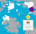
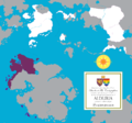 A map nothing the location of the Region of Alduria in the Federation.
 -
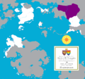 A map noting the location of the Region of the Wechua Nation in the Federation.
 -
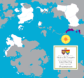 A map noting the location of the Region of Valencia in the Federation.
 -
 A map noting the location of the Region of South Lyrica in the Federation.
 -
 A map noting the location of the Region of Santander in the Federation.
 -
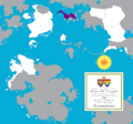
 A map noting the location of the unincorporated territories of Outremer.
 -
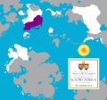
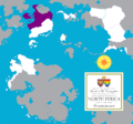 A map noting the location of the Region of North Lyrica in the Federation.
 -
 A map noting the location of the Region of New Luthoria in the Federation.
 -
 A map noting the location of the Region of Isles of Caputia in the Federation.
 -
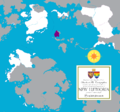
 A map noting the location of the Region of Islas de la Libertad in the Federation.
 -
 A map noting the location of the Federal Capital District in the Federation.


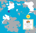
MCS World Map
-
 The Region of Santander.
 -
 The Region of South Lyrica.
 -
 The Region of North Lyrica.
 -
 The Region of New Luthoria.
 -
 The Region of the Isles of Caputia.
 -
 The Region of Valencia.
 -
 The Region of the Wechua Nation.
 -
-
 The Region of Alduria.
 -
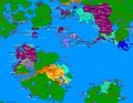 The Federation of Alduria and the Wechua Nation in its entirety.


