Honobe-mika (prefecture): Difference between revisions
From MicrasWiki
Jump to navigationJump to search
(Created page with "{{Sanpantul article}} {{Infobox settlement <!-- See Template:Infobox settlement for additional fields and descriptions --> | name = {{PAGENAME}} | native_name = | native_name_lang = <!-- ISO 639-2 code e.g. "fr" for French. If more than one, use {{lang}} instead --> | settlement_type = | image_skyline = | image_alt = | image_caption = | image_flag = Honobe-mika flag.png | flag_a...") |
No edit summary |
||
| Line 17: | Line 17: | ||
| nickname = | | nickname = | ||
| motto = | | motto = | ||
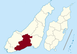
| image_map = Location | | image_map = Location Honobe-mika.png | ||
| map_alt = | | map_alt = | ||
| map_caption = Location of {{PAGENAME}} (marked in red)<br>in [[Sanpantul]] (light yellow) | | map_caption = Location of {{PAGENAME}} (marked in red)<br>in [[Sanpantul]] (light yellow) | ||
Revision as of 21:15, 8 September 2024
| Honobe-mika (prefecture) | |||||
|---|---|---|---|---|---|
|
|||||
| Location of Honobe-mika (prefecture) (marked in red) in Sanpantul (light yellow) |
|||||
| Country | |||||
| Annexed to the Sanpantul | 1724 AN; 8736 ASC | ||||
| Establishment of prefecture | 1729 AN; 8957 ASC | ||||
| Administrative center | Honobe | ||||
| Population | |||||
| • Total | 322,321 | ||||
| Demonym | Honobeni | ||||
| Demographics | |||||
| • Ethnic groups | Sanpō Valencian |
||||
| • Native languages | Sanpanese | ||||
| Time zone | CMT (UTC+5:00) | ||||
| Postcode | 17xxx | ||||


