Tiger River

The Tiger River is one of the most well known rivers in the northern part of Sayaffallah and has achieved a status as one of the most dangerous rivers due to the constant flow of icy run-off that comes from the most mountainous sections of the country. The river runs approximately 600 miles in length flowing out of a mountain glacial fed spring and down to Sayaff Lake
Geography
River name
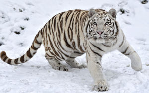
Tiger River achieved its name after its discovery by an explorer and spice trader by the name of Giarelli Von Bellas who is believed to have been looking for an alternate passage through the northern mountains to transport goods without having to cross through the glacial passes. Von Bellas in his journals recorded that a large number of snowy white tigers could be seen drinking from the river and running through the forests on either side.
This was the first instance in which tigers of the snowy variety had been seen in the country at all much less in the northern part of the country. Von Bellas named the river "Tiger River" as a result of his observations and legend has it that Von Bellas was mauled and his body never found resulting in several "legends of von Bellas" to be circulated throughout the common folklore of the country. However the truth is more likely that local villagers spread the legend in order to keep their children close to home and away from the forests which for many generations held both wild animal looking for a meal and bandits seeking fortune.
Hellas Dam
The Hellas Dam is a large hydro-electric dam located approximately 26 kilometers upriver of Sayaff Lake. The hydro-electric dam serves the dual purpose of providing customers in the region with power at low cost and also in controlling the flow of glacial runoff into the lake at the end of the river thus preventing the problems of perpetual flooding from occurring. The dam is monitored and controlled by the Royal Ministry of Energy and regularly hires graduates of the Military College of Sayaffallah to work in its facility.
Modern use and recreation
White water, kayaking, water enthusiasts
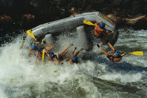
There are several stretches of the river that sport Class III and Class IV and Class V rapids providing kayakers and white water rafters with year round high water volume and excellent world class rapids by which to engage in their recreational passions. Water enthusiasts are however prohibited from exiting the river outside of the controlled exit points due to the high volume of tigers within the forests surrounding the river. The exit points established on the river are several kilometers wide on each side of the river and are fenced in with heavy duty fencing that extends to the water itself and is monitored by game park rangers constantly to provide a safe place free of wildlife for outdoor enthusiasts to access the river.
There are several places in the river where portage is required to continue to other parts of the river that have higher volumes of water, due to the significant danger these portions are closed off to the public except for ranger led expeditions down the river. Despite this being closed off to the public each year there are several hundred civilians and tourists from outside of Sayaffallah who attempt portage and several dozen each year who either go missing or are found dead due to attack by the tigers that live in the general vicinity close to the river.
Dead Man's Gulch
Aptly named due to its high number of fatalities Dead Man's Gulch features consistent Class V rapids for a 16 mile (25km) stretch passing through sheer narrow cliffs and dropping over 60 ft (18 meters)in height during the 16 mile stretch. Dead Man's Gulch is a stretch that rafters are required to have a guide on and kayakers are required to obtain an kayak operational permit to access. Yet despite these requirements several people each year illegally access the section and either become stranded or seriously injured or killed due to the constant level of intensity within this stretch of rapids.
The approach into Dead Man's Gulch is one of rapid intensification, the rapids speed up through Class I-Class IV rapids and then suddenly drops down a plunging waterfall of 10ft (3m) in height before careening around a corner where the river splits around small rocky island with fir trees. After the bend in the river has passed the island entirely the gulch becomes central in view and the river propels itself without any delay into the gulch itself dropping rapidly and increasing its tumult of spray and undertow to the Class V level.
Hunting
Hunters with a exotic zone permit are authorized to hunt a quota of 10 Snowy tigers, approximately 5 of these permits are issued each year allowing for a total of 50 to be hunted and removed from the restricted zone. Despite the scarcity of permits the ranger staff has dealt with illegal poaching of the tigers and other wildlife within the restricted forest zones and has worked with the parliament to establish significant fines and even jail time for those who are caught and prosecuted for disrupting the hunting zone.
Tourism and conservation
The Tiger River's banks along its entirety, except for 30 kilometers used for luxury housing extending from the Hellas Dam down to the Sayaff Lake, are a restricted conservation zone completely closed to access except those on a pre-approved conservation white list. The Tiger River Conservation Zone is maintained by full time staff of rangers who live within the conservation zone and are employed in a dual law enforcement and wildlife management and SAR capacity. The zone encompasses nearly 95% of the 600 mile length of the Tiger River and contains some of the most pristine virgin hardwood pine forests in the world. Access to recreation areas is along a tightly controlled recreation corridor that is completely fenced off from the rest of the restricted conservation zone. Regular checkpoints throughout the recreation corridor as well as video surveillance ensure that wildlife management officers are able to keep visitors safe at all times and conversely ensure that no harmful effects are given to the wildlife within the restricted zones due to visitor traffic.
Tiger River Visitor Center
The Tiger River Visitor Center is a unique and in depth center located at t he source of the river in the glacial mountains in the far north of the country and serves as the only interpretive center along the restricted banks of the river. The Tiger River Visitors Center was built and established in 1902 to provide the general public with a picture of the wildlife that exists within the conservation zone and to show the important work being done by researchers and scientists that live within the zone year round. The visitor center includes a full scale wildlife rehabilitation center in which visitors can see first hand the work being done to care for wildlife that enter into civilian areas and must be rehabilitated for reintroduction into the wild.
The Tiger River Visitors Center includes over 120 kilometers of hiking and backpacking trails through the mountainous areas near the headwater source of the Tiger River. This area is generally safe from predatory wildlife although some snowy tigers have been tracked within 15 kilometers of the Visitor Center prompting warnings to be issued to those out on the trails. As a safety precaution all those who are on the trails are required to wear global positioning service tracking devices and vitals trackers which allow staff at the center to ensure the safety of those on the trails. A fast response team is on call around the clock in the event of an emergency allowing for prompt response with a minimum of delay.
Accessing the Tiger River Visitors Center from Lake Sayaff is a long 600 mile drive through the recreation corridor which extends all the way to the Visitor Center. The drive includes three emergency petrol stations along the route which are manned and staffed around the clock by conservation management rangers who ensure the safety of visitors and wildlife at all times. The Visitor Center includes accommodations at the nearby Glacial Lodge which features access to several hot springs that have now been converted into stone swimming pools for the guests to use at their leisure.


