
|
This article or section is a work in progress. The information below may be incomplete, outdated, or subject to change.
|
The road network of Mercury is the system of roads in Mercury and its territories. Roads are classified according to capacity and purpose, and the rules governing each classification of road vary between types. Drivers of motor vehicles are required to gain a driving licence in order to use the road network.
Classification of roads
Mercury has five classifications of roads, each with differing rules governing their use. A network of "expressways" spans the nation as a whole, being connected to towns and cities via smaller "dual carriageways" and "carriageways". Within towns and cities, the main routes are classified as "byways" while other roads are deemed as "access roads".
| Road type
|
Description
|
Example sign
|
Speed limit
(maximum)
|
Speed limit
(residential)
|
Number of lanes
(each direction)
|
Pedestrians/cycles allowed
|
| Expressway
|
High speed, high capacity inter-state roads, primarily used to travel between major cities.
|

White text on a dark blue background with white border |
130 km/h |
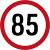
Grade separated from local roads
|
3 + |
No
|
| Dual carriageways
|
High speed inter-city roads, used to travel between the expressway network and minor cities, or between two minor cities.
|

White text on a dark red background with white border |
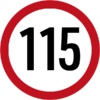 |

|
2 – 3 |
Only on pavement
|
| Carriageways
|
Medium speed inter-town roads, joining dual carriageways or minor cities to smaller towns.
|

Black text on a yellow background with black border |
 |

|
1 – 2 |
Yes
|
| Byways
|
Low speed inner-city roads.
|

Black capitalised text indicating the street name on a white background with black border
|

Not signed
|

Not signed
|
1 |
Yes
|
| Access roads
|
Very low speed, low capacity inner-city roads.
|

Black sentence case text indicating the street name on a white background with black border
|
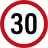
|

|
1 |
Yes
|
Signage
Road markings
Regulations governing use


