Cartography of Nouvelle Alexandrie: Difference between revisions
From MicrasWiki
Jump to navigationJump to search
| Line 8: | Line 8: | ||
==Political== | ==Political== | ||
{{See also|Administrative divisions of Alduria-Wechua}} | {{See also|Administrative divisions of Alduria-Wechua}} | ||
<gallery></gallery> | <gallery> | ||
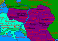
File:Alduria-region-map.png|Map of the Region of [[Alduria]]. | |||
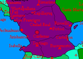
File:Wechua-Nation-region-map.png|Map of the Region of the [[Wechua Nation]]. | |||
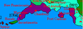
File:Santander-region-map.png|Map of the Region of [[Santander]]. | |||
File:Valencia-regional-map.png|Map of the Region of [[Valencia]]. | |||
File:Cardenas-regional-map.png|Map of the [[Cárdenas|Federal Capital District]]. | |||
</gallery> | |||
==Demographic== | ==Demographic== | ||
Revision as of 21:36, 25 August 2020

|
This article or section is a work in progress. The information below may be incomplete, outdated, or subject to change. |
The cartography of Alduria-Wechua is the history of geographical surveys and the creation of maps of the Federation of Alduria and the Wechua Nation.
History
Physical
Political
-
 Map of the Region of Alduria.
 -
 Map of the Region of the Wechua Nation.
 -
 Map of the Region of Santander.
 -
 Map of the Region of Valencia.
 -
 Map of the Federal Capital District.


