Kuala Forajasaki: Difference between revisions
No edit summary |
No edit summary |
||
| (3 intermediate revisions by the same user not shown) | |||
| Line 17: | Line 17: | ||
| pushpin_mapsize = | | pushpin_mapsize = | ||
| pushpin_map_caption = | | pushpin_map_caption = | ||
| image_dot_map = Forajasaki Map.png | | image_dot_map = Forajasaki Map (02-2023).png | ||
| dot_mapsize = 300px | | dot_mapsize = 300px | ||
| dot_map_base_alt = Kuala Forajasaki location | | dot_map_base_alt = Kuala Forajasaki location | ||
| dot_map_alt = | | dot_map_alt = | ||
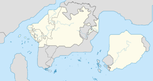
| dot_map_caption = Location of Kuala Forajasaki in [[Forajasaki]] | | dot_map_caption = Location of Kuala Forajasaki in [[Forajasaki]] | ||
| dot_x = | | dot_x = 66 |dot_y = 73 | ||
| coordinates = | | coordinates = | ||
| subdivision_type = Country | | subdivision_type = Country | ||
| Line 48: | Line 48: | ||
| blank2_info = | | blank2_info = | ||
| website = | | website = | ||
| timezone = [[Time | | timezone = [[Kuala Forajasaki Time Time]] | ||
| utc_offset = +4 | | utc_offset = +4 | ||
}} | }}'''Kuala Forajasaki''' ([[Wikipedia:Malay language|Phineaner]] for 'Forajasaki River Mouth'; [[Wikipedia:Jawi script|Jawi]]: كوالا فورجاسكي) is the [[Wikipedia:Capital city|capital]] and largest city (most populous city) in [[Forajasaki]]. Kuala Forajasaki is located at the mouth of the [[Forajasaki River]], on the west coast of Forajasaki. Its population is 2.3 million people in {{RP|2020}} compared to an estimated 2.8 million people in {{RP|2010}}. The capital is located about 24 kilometers northeast of [[Da Toh Town]], 30 kilometers south of the capital of the autonomous region of [[Ghawur]], [[Pasawi]], and 36 kilometers north from the state capital of [[Barine]], [[Kota Batang Rumput]]. | ||
Kuala Forajasaki houses several local and federal government offices, it is also the seat of the [[Government of Forajasaki|Forajasaki federal government]] and the [[High Council of the Phineonesian Nations]]. The city is home to members of the [[Kuala Forajasaki Sultanate]] as the [[President of Forajasaki]] also known as the ''Ruler of the State'' ({{Lang-ms|Yang Menguasai Negara}}). | |||
== History == | |||
== Geography == | |||
=== Climate === | |||
== Government == | |||
== Economy == | |||
== Utility == | |||
=== Water === | |||
=== Electricity === | |||
=== Telecommunications === | |||
== Demographics == | |||
== Transportation == | |||
== Culture == | |||
=== Sports === | |||
=== Media === | |||
=== Tourist attractions === | |||
== Education == | |||
== See also == | |||
[[Category:Cities]] | [[Category:Cities]] | ||
Latest revision as of 08:29, 13 February 2023

|
This article or section is a work in progress. The information below may be incomplete, outdated, or subject to change. |
| Kuala Forajasaki كوالا فورجاسكي |
|
|---|---|
| Capital city / Metropolis | |
| Bandaraya Kuala Forajasaki | |
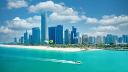
| Kuala Forajasaki skyline | |
| Country | |
| State | Kuala Forajasaki |
| Municipal region | Central Capital District |
| Government | |
| • Type | Municipality |
| • General Manager of City Municipality | |
| Elevation | 27 m (89 ft) |
| Population (RP 2617) | |
| • Total | 2,390,080 |
| Demonym | Kuala Forajasakian |
| Time zone | Kuala Forajasaki Time Time (UTC+4) |
Kuala Forajasaki (Phineaner for 'Forajasaki River Mouth'; Jawi: كوالا فورجاسكي) is the capital and largest city (most populous city) in Forajasaki. Kuala Forajasaki is located at the mouth of the Forajasaki River, on the west coast of Forajasaki. Its population is 2.3 million people in RP 2616 compared to an estimated 2.8 million people in RP 2606. The capital is located about 24 kilometers northeast of Da Toh Town, 30 kilometers south of the capital of the autonomous region of Ghawur, Pasawi, and 36 kilometers north from the state capital of Barine, Kota Batang Rumput.
Kuala Forajasaki houses several local and federal government offices, it is also the seat of the Forajasaki federal government and the High Council of the Phineonesian Nations. The city is home to members of the Kuala Forajasaki Sultanate as the President of Forajasaki also known as the Ruler of the State (Phineaner: Yang Menguasai Negara).

