Kōriyama (prefecture): Difference between revisions
From MicrasWiki
Jump to navigationJump to search
(Created page with "{{Infobox settlement <!-- See Template:Infobox settlement for additional fields and descriptions --> | name = {{PAGENAME}} | native_name = | nat...") |
No edit summary |
||
| Line 8: | Line 8: | ||
| image_alt = | | image_alt = | ||
| image_caption = | | image_caption = | ||
| image_flag = Koteku | | image_flag = Flag of Koteku.png | ||
| flag_alt = | | flag_alt = | ||
| image_seal = | | image_seal = | ||
Revision as of 19:41, 9 April 2020
| Kōriyama (prefecture) | |||
|---|---|---|---|
|
|||
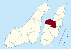
| Location of Kōriyama (prefecture) (marked in red) in Sanpantul (light yellow) |
|||
| Country | |||
| Claimed by the Empire of Sanpantul | 1675 AN; 7307 ASC | ||
| Establishment of prefecture | 1679 AN; 7427 ASC | ||
| Administrative center | Kōriyama | ||
| Population | |||
| • Total | 400,000 | ||
| Demonym | Kotekese | ||
| Demographics | |||
| • Ethnic groups | Sanpō Tellian |
||
| • Native languages | Sanpanese | ||
| Time zone | CMT (UTC+5:20) | ||
| Postcode | 74xxx | ||

