Franja Transversal del Oeste: Difference between revisions
From MicrasWiki
Jump to navigationJump to search
No edit summary |
No edit summary |
||
| Line 41: | Line 41: | ||
|} | |} | ||
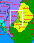
The '''Franja Transversal del Oeste''', or Western Transversal Strip, | The '''Franja Transversal del Oeste''', or Western Transversal Strip, was a landlocked territory in [[Keltia]] that existed from 1663-1673. It was located north of the coast of the [[Captive Sea]], bordered by the [[Wechua Nation]] to the east, [[Caputia]] on the north and the west, and the Security Lines separating it from both nations. The strip has been under military occupation by the [[Wechua Nation]], and later jointly with [[Caputia]], since the collapse of [[Alexandria]] and the end of the [[Hammish Civil War | Hammish civil war]]. | ||
The strip is populated with Alexandrian refugees from the collapse of Alexandria, mainly from its old Keltian provinces of Valencia and Santander, and other refugees from the interior of Keltia that joined the assembling tent cities and refugee camps. | The strip is populated with Alexandrian refugees from the collapse of [[Alexandria]], mainly from its old Keltian provinces of Valencia and Santander, and other refugees from the interior of Keltia that joined the assembling tent cities and refugee camps. | ||
==Name== | ==Name== | ||
Latest revision as of 00:04, 17 March 2020
 Flag | |
 Coat of Arms | |
 Map of the Franja Transversal del Oeste. | |
| Motto: | In pace victoria (In Peace, Victory) |
| Capital | OB-1 |
| Military Districts | District I District II District III |
| Official Languages | Common Tongue, Praeta, Alexandrian Fransch, Wechu. |
| Demonym | XXXXXX |
| Government | Military Occupation by Caputia and the Wechua Nation |
| Head of State | Sapa Wechua HWM Manco Capac |
| Head of Government | General Bernard Gardet (Caputia) General Urma Ccahua Chalco (Wechua Nation) |
| Legislature | XXXXX |
| Population | 1,287,322 (1666) |
The Franja Transversal del Oeste, or Western Transversal Strip, was a landlocked territory in Keltia that existed from 1663-1673. It was located north of the coast of the Captive Sea, bordered by the Wechua Nation to the east, Caputia on the north and the west, and the Security Lines separating it from both nations. The strip has been under military occupation by the Wechua Nation, and later jointly with Caputia, since the collapse of Alexandria and the end of the Hammish civil war.
The strip is populated with Alexandrian refugees from the collapse of Alexandria, mainly from its old Keltian provinces of Valencia and Santander, and other refugees from the interior of Keltia that joined the assembling tent cities and refugee camps.
Name
History
Geography
Political geography
Governance
Overview
Wechua Administration
Joint Wechu-Caputian Administration
Security Lines
Crossing Points
Economy
Demographics
Infrastructure
Transportation and Communications
See also
- This;
- And this.