King's Sentinels

The King's Sentinels are a group of two pairs of oceanic rocks in the Northern Sea, at the edge of the permanent arctic ice fields, north of Apollonia. The King's Sentinels were first mapped around VI.1568 AN. The rocks are basalt outcrops formed from the eroded plugs of ancient volcanoes once active in the Northern Sea. The eastern pair, consisting of Sundharu and Ukko's Rock, lie off the western shore of the Grand Duchy of Iselande. The western pair, consisting of Magna Stack, the largest rock, and Nova Stack, lie north of Saksenlant in Lac Glacei.
Geography
| Nearest land | Distance | Height above sea | Notes | |
|---|---|---|---|---|
| Magna Stack | Zeivsbuurg, |
378 km S | 542 m | Largest rock |
| Nova Stack | 319 km S | 145 m | ||
| Ukko's Rock | 99.2 km E | 17.4 m | Smallest rock | |
| Sundharu | 54.3 km E | 36.1 m | Home to Sundharu Rock Lighthouse |
Ownership
The rocks are claimed by the Kingdom of Meckelnburgh and administered as part of constituent country Iselande. In 1719 AN, the Kingdom of Meckelnburgh, needing aids to navigation in the Northern Sea on its route between Meckelnburgh and Iselande, sent its Royal Navy to the rocks and claimed them for Queen Ĉielero III. The Meckelnburgh Royal Saeweard subsequently constructed the Sundharu lighthouse on its eponymous island, the closest to Iselande.
As "rocks" rather than "islands," the King's Sentinels do not possess their own exclusive economic zones.
Ecology
Up to a dozen seabird species use the various formations on the King's Sentinels for migration and, in the summer months, nesting. Beneath the water, various mollusks, such as clams, cling to the rocks.
Gallery
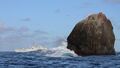
Royal Meckelnburgh Navy at Ukko's Rock
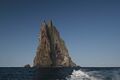
Magna Stack
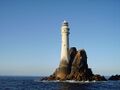
Sundharu Rock Lighthouse


