Pan-Keltian Highway
| |

| |
| Construction started: | 1693 AN |
| Construction finished: | 1706 AN |
|
| |
| Country: | |
|
| |
| Constituent highways: | |
| Construction works done by: | |
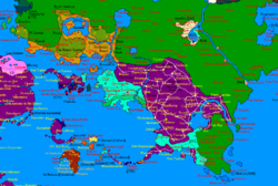
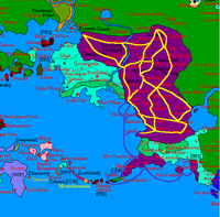
The Pan-Keltian Highway is a transportation megaproject built by the federal government of Nouvelle Alexandrie as part of the New Prosperity Plan, and expanded greatly in the northwest of the continent by The Hexarchy through 1730 AN as part of its own Comprehensive Infrastructure Plan. The project started with the general purpose of better connecting the Federation's Keltian territory, especially the rapidly developing and growing Regions of Wechua Nation, Santander, and Valencia. The highways also aimed to better connect the new capital city, Cárdenas, with the rest of the country. The project also repairs, expands, and modernizes the existing system of roads in the Wechua Nation, called the Qhapaq Ñan. On the side of The Hexarchy, the plan was aggressively pursued within their own respective borders as a method of efficiently and quickly spurring national growth and the building of further national infrastructure. The highway will be designed in similarity with the Pan-Euran Highway.
The project also includes the "Keltian Marine Highway", a ferry service to connect Santander (completed), New Luthoria (planned), and Valencia (completed) over water. The marine component of the highway shall be operated by KelMAR, a joint-venture by the federal government and Kerularios & Company.
The portions of the Pan-Keltian Highway that cross into neighboring nations have been built and optimized for ease of connection to neighboring highway systems. Before 1700 AN, no realistic plans to connect the highway project with Keltian neighbors were announced until The Hexarchy managed to secure and build infrastructure for a safe land border with the Wechua Nation, which arose from Nouvelle Alexandrie growing into a larger state. The southern half of the route traverses the mountainous central Wechua regions and the Rodinia river, which posed formidable engineering challenges. The northern half of the highway runs through The Hexarchy, with final stretches of the highway under construction to connect with the Dark Berry Islands to the far west and with Lysstyrer to the far north of the continent, with further improvements made through the building of major routes through 1730 AN that connect to the Great Sandy Desert as well as borders near The Green in the country's bitterly cold, formerly isolated northern regions.
The highway will be fitted with sophisticated electronic surveillance measures and advanced vehicle collision absorption measures, with The Hexarchy's government gradually following suit with plans of their own. Due to the special relationship now existing between The Hexarchy and New Alexandria, border controls between the two countries are light, making land travel all the way to parts of Apollonia finally a realm of possibility, despite the extreme engineering challenges that will no doubt arise during construction.
Nouvelle Alexandrie
Routes
- C1: Taulliraju-Parap-Huichajanca-Auquimarca-Rimarima-Kapillayuq-Ciudad Real-Cárdenas-Jirishanca
- C6: Santurce-Waytapallana-Rimarima-Pucallpa-Qusqu-Viseu-Puerto Carrillo
- C8: Cochabamba-Vuevo Dux-Arequipa-Ancash-San Luis- Junín-Santurce-San Francisco-Wechuahuasi-Jirishanca-Santiago-Artes
- C8A: San Luis-Apurimaq
- C14: Parap-Roanne-Apurimaq-Waytapallana
- C15: Cajamarca-Taulliraju-Huichajanca-Aimara-Qusqu-Alpamayo
- C18: Artés-L'Triomphe-Bassumorto-Castellón-Rossello-Acevedo-Alpamayo-Viseu-Punta Carolina-Mancos-San Juan
- C18A: Bassumorto-Santiago-Isabella
- C22: Parap Ring Road
- C24: Judah-Midyan-Cochambamba-Callao-Huancavelica-Parap
- C28: Ciudad Real-Potosí-Rossello
- C28A-Cárdenas-Potosí-Castellón
- C30: Roanne-Kedah-Arequipa
- C33: Vela-Hato Rey-Loíza-Sisa-Achiyaku
- C33A: Loíza-Puerto Carrillo
- C35: Mayenne-Chambéry
- C48: Rimarima Ring Road
- C55: Cárdenas Outer Ring Road
- C56: Cárdenas Inner Ring Road
- C61: Potosí Ring Road
- C65: Qusqu Ring Road
- C88: Chambéry-New Franciscania-Trevoux-Saint-Cloud-Isabella (Under Construction)
