Maps of the Republic of the United Cities in the Lanzerwald: Difference between revisions
From MicrasWiki
Jump to navigationJump to search
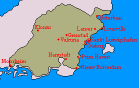
(Created page with "{{Lanserwoud Article}} thumb|Basic map depicting the cities of the republic. File:Language map lanzerwald.png|thumb|Map dep...") |
No edit summary |
||
| Line 1: | Line 1: | ||
{{Lanserwoud Article}} | {{Lanserwoud Article}} | ||
{{multiple image | |||
| align = center | |||
| direction = horizontal | |||
| width = | |||
| image1 = Basic map of the lanzerwald republic.png | |||
| width1 = 278 | |||
| alt1 = | |||
| caption1 = Basic map of the lanzerwald republic.png|Basic map depicting the cities of the republic. | |||
| image2 = Language map lanzerwald.png | |||
| width2 = 278 | |||
| alt2 = | |||
| caption2 = Map depicting the majority language spoken in different regions of the republic, with purple depicting Alexandrian, orange Cibolan-Diets and dark grey depicting South-Cibolan Saxon. | |||
}} | |||
[[Category:Maps]] | |||

