Korhalistan
From MicrasWiki
Jump to navigationJump to search
| Korhalistan Rajya कोरहलिस्तान राज्य | |||
| Princely state of Great Apollonia | |||
| |||
| Community | Çakari Community | ||
| Subdivision | State | ||
| Capital | Çakarabad | ||
| Largest cities | Manbai | ||
| Area | 696,888 km2 | ||
| Population | 44,484,758 (estimation in 1698) | ||
| Raja | Manikarnika Tambe rani reejent Anand Çakar formal raja | ||
| Legislature | Rajya Sabha (Council of the Kingdom) | ||
| Languages | Common Tongue (administrative) Adarani (official) | ||
| Time Zone | CMT+1 | ||
| Driving side | left | ||
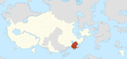
Korhalistan, officially the Korhalistan Rajya (Adarani: कोरहलिस्तान राज्य), is a state of Great Apollonia, located between Lake Jodha in the north, Dyre Straits in the south and the Green Border in the east.
The name Korhal first appears on the map in 1534 AN. The area was under the Antican flag at the time. After the area had fallen to the Green and foreign occupation for a period, the area again acquired its own identity and the name Korhal returned as Korhalistan.
Area
Korhalistan borders Poorajangal to the north, Ardnusur and Hasanistan to the east and Floria and Haritdesh to the west.
- Area:
- Total: 696,888 km2
- Aydin: 12,456 km2
- Rulak: 14,760 km2
- Border nations:
- Confederate States of Floria: 132 km
- Coastline: 3,204 km


