File:CaputianBorderDefenseFence.jpg

Original file (1,024 × 752 pixels, file size: 208 KB, MIME type: image/jpeg)
See: http://caputia.mncommunities.org/community/showthread.php?tid=977
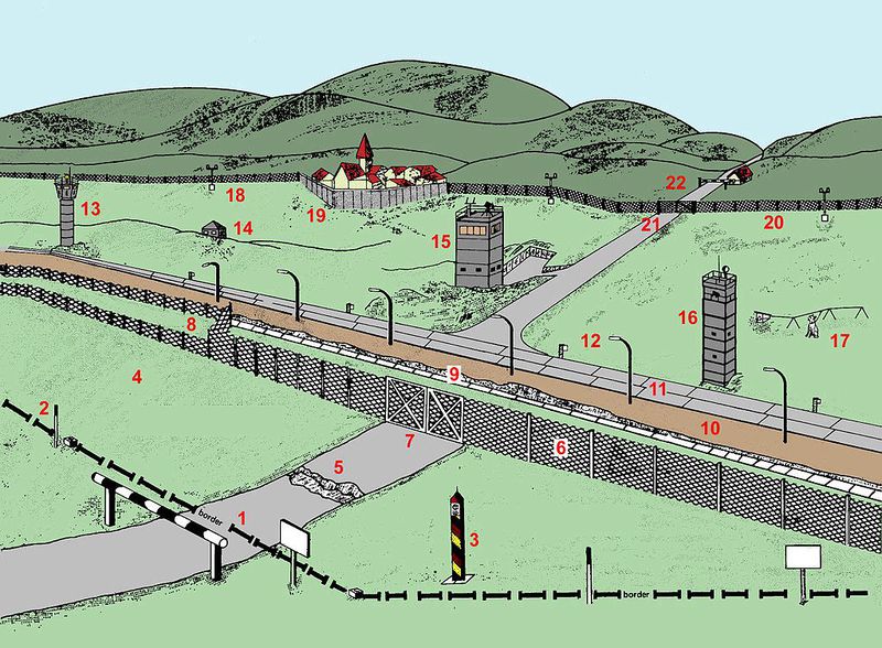
The border (1) shown in the diagram cuts across a road which formerly linked north and south. Proceeding from west to east, the zonal border is marked on the western side by signposts (2) saying "STOP HERE, BORDER".
Just behind the border, there is a border marker pole (3) with diagonal black, red and yellow stripes. The border is otherwise unmarked until the fortifications begin well into Caputian territory, leaving a strip of unfortified borderland (4).
A short distance after the zonal border, i.e. on the Caputian side, the road is dug up (5), so there is an anti-vehicle ditch across its whole width. Then follows a metal-mesh fence (6), with a double gate (7) where the road is. To the left of the road, the metal-mesh fence forks to form a double fence (8); the area between the two fences is mined. Near the road, instead of a second metal-mesh fence, there is a concrete-faced anti-vehicle ditch (9). Next follows a flood-lit control strip (10); behind that, a guard patrol road running parallel to the border (11). After that comes a strip of open green territory containing various types of guard towers (13, 15, 16), a dog run (17) and an observation bunker (14); this is delimited by a signal fence which has floodlights spaced at regular intervals (18). The signal fence curves around a village (19) that is close to the border, excluding it from the border strip. Where it crosses the road, the signal fence has a gate (21), and further up the road, i.e. deeper in Caputian, the road is blocked by a horizontal barrier, beside which there is a little house (22).
Electronic sensors and detectors are included in the border security fence, along with ground penetrating radar and other facilities and technologies to improve effectiveness and security.
File history
Click on a date/time to view the file as it appeared at that time.
| Date/Time | Thumbnail | Dimensions | User | Comment | |
|---|---|---|---|---|---|
| current | 14:48, 13 March 2018 |  | 1,024 × 752 (208 KB) | Edgard (talk | contribs) | See: http://caputia.mncommunities.org/community/showthread.php?tid=977 The border (1) shown in the diagram cuts across a road which formerly linked north and south. Proceeding from west to east, the zonal border is marked on the western side by signpo... |
You cannot overwrite this file.
File usage
There are no pages that use this file.