Cartography of Nouvelle Alexandrie: Difference between revisions
| Line 10: | Line 10: | ||
===Bucolos & Fils, Cartographer=== | ===Bucolos & Fils, Cartographer=== | ||
<gallery> | <gallery> | ||
File:AWF WechuaNation 1688AN.png|A map noting the location of the Region of [[ | File: AWF Alduria 1688AN.png|A map nothing the location of the Region of [[Alduria]] in the Federation. | ||
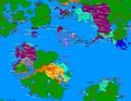
File:AWF WechuaNation 1688AN.png|A map noting the location of the Region of the [[Wechua Nation]] in the Federation. | |||
File:AWF Valencia 1688AN.png|A map noting the location of the Region of [[Valencia]] in the Federation. | File:AWF Valencia 1688AN.png|A map noting the location of the Region of [[Valencia]] in the Federation. | ||
File:AWF SouthLyrica 1688AN.png|A map noting the location of the Region of [[South Lyrica]] in the Federation. | File:AWF SouthLyrica 1688AN.png|A map noting the location of the Region of [[South Lyrica]] in the Federation. | ||
Revision as of 17:15, 17 September 2020

|
This article or section is a work in progress. The information below may be incomplete, outdated, or subject to change. |
The cartography of Alduria-Wechua is the history of geographical surveys and the creation of maps of the Federation of Alduria and the Wechua Nation.
History
Physical
Political
Bucolos & Fils, Cartographer
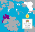
A map nothing the location of the Region of Alduria in the Federation.
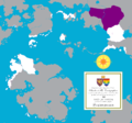
A map noting the location of the Region of the Wechua Nation in the Federation.
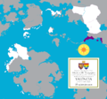
A map noting the location of the Region of Valencia in the Federation.
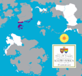
A map noting the location of the Region of South Lyrica in the Federation.
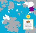
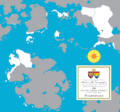
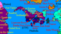
A map noting the location of the Region of Santander in the Federation.
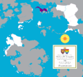
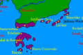
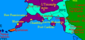
A map noting the location of the unincorporated territories of Outremer.

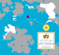
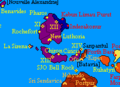
A map noting the location of the Region of North Lyrica in the Federation.
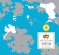
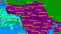
A map noting the location of the Region of New Luthoria in the Federation.
A map noting the location of the Region of Isles of Caputia in the Federation.
A map noting the location of the Federal Capital District in the Federation.


MCS World Map

The Region of Santander.
The Region of South Lyrica.
The Region of North Lyrica.
The Region of New Luthoria.
The Region of the Isles of Caputia.
The Region of Valencia.
The Region of the Wechua Nation.
The Region of Alduria.
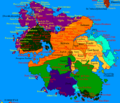
The Federation of Alduria and the Wechua Nation in its entirety.


