Barikalus
| Emirate of Arbor إمارة أربور 'Imart 'Arbur | |||
| |||
| Motto: Justice and Faith (Arboric: العدل والإيمان) | |||
| Anthem: | |||

| |||
| Map versions | 9.4b – 16.6.4 (as Kingdom of Amokolia) 16.6.5 – 16.8.3b (as Frankish Empire) 16.9.0 (as Emirate of Arbor) | ||
| Capital | Al-Hamra | ||
| Largest city | Madinat al-Fath | ||
| Official language(s) | Arboric | ||
| Official religion(s) | Craitism | ||
| Demonym | Arbor | ||
| - Adjective | Arborish | ||
| Government | Hereditary monarchy | ||
| - Emir أمير | Mahmud bin Alsalam | ||
| - Grand vizier وزیر اعظم | Mustafa Asada | ||
| - Legislature | Majlis al-Imar مجلس الإمارة | ||
| Establishment | 1504 AN as Amokolia 1678 AN as Francia 1685 AN as Emirate of Arbor | ||
| Area | 1,015,416 km2 | ||
| Population | 44,429,733 (1689 AN) | ||
| Active population | 2 | ||
| Currency | Gold dinar (Arboric: ﺩﻳﻨﺎﺭ ذهبي) | ||
| Calendar | |||
| Time zone(s) | CMT+8 and CMT+10 | ||
| Mains electricity | |||
| Driving side | right | ||
| Track gauge | |||
| National website | Nation Portal | ||
| National forum | Forum of Arbor | ||
| National animal | Camelus dromedarius | ||
| National food | Falafel | ||
| National drink | Coffee | ||
| National tree | Date palm | ||
| Abbreviation | EOA and AB | ||


Arbor, officially the Emirate of Arbor (Arboric: إمارة أربور), is a sovereign nation in southeast Keltia. It is a hereditary monarchy consisting of three geographical regions separated by the Eastern Ocean. The capital is Al-Hamra, located on the largest island of the Arbor Isles.
The nation sees itself as a continuation of the earlier Kingdom of Amokolia and the Frankish Empire. Moreover, the population consists for the most part of fugitive citizens of Arcadia, Francia, Helderbourgh and Stormark. As a result, the country is multi-ethnic and multicultural, dominated by an ever-growing fusion of cultures into a common Arborish culture. This is expressed in a common language, Arboric, and conversion to a new religion, Craitism.
Although Al-Hamra is the official capital, many public institutions are located in Madinat al-Fath. This has to do with the strict class policy. People who are recognised in class III are allowed to enter the capital, which means that part of the population has no access. In order to make public institutions accessible to all classes, they are located in Madinat al-Fath.
Name
The name "Arbor" was given to the archipelago during the Storish era. The name is Catologian for 'trees', referring to dense forestation on the islands. With the foundation of the Emirate that name was used for this new state. The name has been transliterated in the Arboric into 'arbur (أربور).
The nickname of the nation is: imart juzur alfirdaws walwahhat alrrayiea (Arboric: إمارة جزر الفردوس والواحات الرائعة), meaning 'the Emirate of paradisiacal islands and delightful oases’.
Accessibility and isolation policy

Since the foundation of the emirate, the country has pursued a strict isolation policy. This had to change when a large expansion of territory took place in 1686 AN. The government of the emirate changed the policy to three layers of accessibility:
- Class I: With a simple visa and Livists can stay in limited areas. For a visa there is a maximum length of stay of three months, after which one has to leave the country for at least one month. Livists must be in quarantine for at least two weeks on arrival, wearing an ankle tag during their stay and on their clothes a visible yellow sign consisting of an Arboric letter "lām" (ل). If Livists are found outside the restricted areas, they can be expelled immediately and a permanent ban on entry to the country.
- Class II: A visa allows citizens of approved countries in this class to visit large parts of the emirate. Only the Arbor Isles, except the island of Jazirat 'Uwyastar, cannot be visited. Exception is for diplomats who have to successfully pass the Gate of Justice.
- Class III: Only believers in the Craitgod from approved countries can get a visa for the whole emirate. The visa is marked with a red crescent moon, but when granted one may be asked to pray in the Dome of Peace and pass through the Gate of Justice.
Geography
Since its expansion in VIII.1686 AN, the emirate acquired a greater diversity of geography. Roughly speaking, it is divided into three geographical regions:
Arbor Isles
The Arbor Isles, Juzur 'Arbur (Arboric: جزر أربور), are seen as lone and mysterious islands on Micras. Previously, the archipelago was known as Terra Firma. There are three main Arbor Isles, surrounded by many smaller islands. Of those smaller islands, the island of Jazirat 'Uwyastar the well-known. This island is artificial to provide sufficient space for the international airport and port.
- Area and boundaries of the Arbor Isles:
- Area: 64,368 km2
- Coastline: 312 km
- Area and boundaries of the Arbor Isles:
The landscape of the islands is characterised by woodlands, almond trees, fertile plains and often dramatic coastlines with sandy coves separated by craggy cliffs. The highest peak of the islands is Dhurwat Ardiat Thabita (Arboric: ذروة أرضية ثابتة): Peak Terra Firma, located on Jazirat al-Musawa. The mountain is 1,445 metres high on the north side of the island.
Overview of the three main islands:
| Island | Fonetic name | Name in Common Language | Land area (km2) |
|---|---|---|---|
| جزيرة الحرية | Jazirat Alhuriya | Liberty Island | 11,520 |
| جزيرة المساواة | Jazirat Almusawa | Equality Island | 37,800 |
| جزيرة الأخوة | Jazirat Al'ukhua | Fraternity Island | 15,048 |
The easternmost of the three main islands, Jazirat Al'ukhua, lies 768 km west of South Island of the Keltia continent.
Isles of the Fortunate and North Island
This geographical region is treated as one for topographical reasons, but the physical geographies of the Isles of the Fortunate and North Island are completely different. Only the Arbor area on North Island is relatively small compared to other geographical regions.
Isles of the Fortunate
Juzur al-Mahzuzin (Arboric: جزر المحظوظين): isles of the fortunate
- Area and boundaries of the Isles of the Fortunate:
- Area: 131,688 km2
- Coastline: 3,180 km
- Area and boundaries of the Isles of the Fortunate:
North Island
Jazirat al-Shamalia (Arboric: الجزيرة الشمالية): north island, or Jazirat Kiltik al-Shamalia (Arboric: جزيرة كيلتيك الشمالية): Keltic north island.
- Area and boundaries of the North Island:
- Area: 14,112 km2
- Bordering The Green: 312 km
- Coastline: 120 km
- Area and boundaries of the North Island:
Western Territories
The area of Arbor on the continent of Keltia has so far no separate designation, but is often called the al-Manatiq al-Gharbia (Arboric: المناطق الغربية): western territories. In addition to a portion on the continent, the area also includes the coastal islands.
- Area and boundaries of the Western Territories:
- Area: 805,248 km2
- Border nations:
- Haifo-Pallisican Imperial Trade Union: 348 km
- The Green: 768 km
- Coastline: 7,884 km
- Area and boundaries of the Western Territories:
An elongated mountain range, Jibal al-Ahmar (Arboric: جبال الأحمر): the Red Mountains, running from west to east, parallel to the coast of the Sea of Storms. The mountain range is interrupted by a large bay, Dabab al-Sabah (Arboric: ضباب الصباح): Morning Mist Bay. As a result, the mountain range is also referred to as the Western Red Mountains, Jibal al-Ahmar al-Gharbia (Arboric: جبال الأحمرالغربية) and the Eastern Red Mountains, Jibal al-Ahmar al-Sharqia (Arboric: جبال الأحمر الشرقية).
South of the Red Mountains lies a fertile coastal strip, Qitae al-Bahr (Arboric: قطاع البحر): Sea strip, with many ports. This has become one of the most urbanised and densely populated areas of the western territories. The Eastern Red Mountains reach to the sea, to the south-easternmost cape marking the formal boundary between the Sea of Storms and the Eastern Ocean.
The Red Mountains also form the monsoon border. The annual rainy season, the monsoon (Arboric: موسم), remains south of the mountain range. This means that there is almost no rain north of the mountain range, only wadis (Arboric: وَادِي) are filled by the monsoon rains. The interior is therefore a desert area, where oases can be found here and there. Summer storms in the sandy desert can cause heavy sand and dust storms, which even blow the sand over the Red Mountains on the coastal strip.
Off the coast are several islands, the largest of which is Mayurqa (Arboric: مايوركا): large island. The sea between the islands and the mainland is called al-Bahr al-Mutawasit (Arboric: البحر المتوسط): Middle Sea. Despite the great connections with the Sea of Storms and the Eastern Ocean, the coasts of the Middle Sea enjoy a Mediterranean climate. This is due to the fact that the ocean currents pass east and south of the coastal islands. The rise of the monsoon cools the warm climate and brings much needed rain. The Middle Sea is relatively shallow, so the sea is rich in coral reefs.
Overview of the largest islands, from west to east:
| Island | Fonetic name | Name in Common Language | Land area (km2) |
|---|---|---|---|
| جزيرة الأسود | Jazirat al-Aswad | Black Island | 33,192 |
| جزيرة طويلة | Jazirat Tawila | Long Island | 9,432 |
| مايوركا | Mayurqa | Larger Island | 70,056 |
| منورقة | Manûrqa | Smaller Island | 4,968 |
| جزيرة الماعز | Jazirat al-Maeiz | Goat island | 15,552 |
| جزيرة قرطبة | Jazirat Qurtuba | Qurtuba Island | 31,176 |
| الجزيرة الخضراء الجنوبية | al-Jazeera al-Khadra al-Janubia | Southern Green Island | 32,760 |
| الجزيرة الخضراء الشمالية | al-Jazeera al-Khadra al-Shamalia | Northern Green Island | 9,288 |
Besides these islands there are many smaller islands, such as the Juzur Nafijatur (Arboric: جزر نافيجاتور): Navigator Islands, southeast of Manûrqa.
History
- See also the Timeline of Arbor
Arbor Spring
In the disastrous year of 1685, the very young Franco-Batavian Empire shook its foundations. A plot to overthrow the Kaiser von Francia and King of Batavia was carried out. At the same time, the ancient High Realm of Stormark fell and disappeared from Micras. A power vacuum arose.
On the way to Batavian Cibola, Arkadius Frederik Gustavus of Vinandy was poisoned. A bottle of whiskey he received from a loyal friend contained poison. This put the Kaiser in a coma. Because the Imperial Frankish Guard had not checked this bottle, a power struggle arose with the Tassity Mansabdar. The plane with the Kaiser and his family was therefore flown to the Arbor Isles. That archipelago was a jarldom of Stormark, which had not long before been granted to the Kaiser.
The chaos was complete when communication with the outside world was cut off. The Frankish Empire became ungovernable because the Kaiser and the Regent were missing. The Chancellor was shot, the Amokolian Highlanders turned against the Franks. In Batavia it was still possible to keep the country together on the continent of Benacia. But Arcadia, Batavian Cibola and Helderbourgh ceased to exist.
The remaining loyal troops of the Tassity Mansabdar together with the loyal Imperial Frankish Army formed a new force: the Muharibu Alhuriya (Arboric: محاربو الحرية). To protect their Kaiser, the Arbor Isles were isolated and cut off from the outside world. This created a new state, which sees itself as the only legitimate successor to the Frankish Empire: the Emirate of Arbor. The comatose Kaiser was declared an emir. He was given the name: Mahmud bin Alsalam, meaning: the praiseworthy son of peace.
The news of the emirate's foundation became known all over Micras, causing the stateless and former Stormarkians to hope for a safe haven. The central person they hoped for is the emirate. Her Storish roots are obvious, but for the Normans felt connected to her because she was their Imperial Chieftain. Together with the Jorviks, the Normans organized an armada of ships to sail as many people as possible to the Arbor Isles. The local militia, consisting mainly of former soldiers, had gained control of all kinds of weaponry. Among them were ships, submarines, fighter jets, helicopters, tanks, etc. Weapons were also collected from other former Storish areas, only what was left behind was destroyed.
The rumours that an armada was on its way to Arbor were not believed. Too unlikely. But it turned out to be true. Hundreds of ships of all sizes sailed the Arbor Isles. When they arrived, they were received by the Emira herself. The refugees were grateful that they were allowed to come, but also declared that they would no longer appear in public as skyclad. Micras is too unsafe for such a free expression.
With the prospect of the Kaiseress becoming a stateholder, the fugitive community of Froyalaners was alarmed. Some young people wanted to take up arms in order to obtain freedom by force. But this was not strategically feasible and did not have the support of the entire community. The reports about the armada and its shelter in the Emirate gave hope. In a petition, the Froyalan community asked for support to leave for Arbor. The Grand Vizier announced that the refugees were welcome, after which he sent ships to the Corprian Archipelago to explore a residential area there.
That same day the Grand Vizier was told that an alien ship had arrived in the port of Jazirat 'Uwyastar. This ship brought representatives of the lost tribes of the Torosh and Souf. They came to plead for the favour of the Emir to include their homeland into the Emirate. An expeditionary corps was sent out to explore the tribes' land. In this way the borders were determined and the area was annexed by the Emirate. The area was referred to as al-Manatiq al-Gharbia (Arboric: المناطق الغربية): western territories. This expansion forced the isolation and access policy to be changed, because the strict policy could not be maintained.
On 3.VIII.1687 AN the Emir awoke from his coma. When the news of the coma became known, people celebrated all over the Emirate. The Emir is alive and awake!
Demography
Before 1685 there were approximately 10.5 million people living on the Arbor Isles. When the Frankish Kaiser fled to the islands and then the emirate was founded, a large stream of refugees came to the islands to seek refuge. The refugees mainly come from Arcadia, Francia and Stormark.
| 1685 | 1686 | 1687 | 1688 | 1689 | |
|---|---|---|---|---|---|
| Arcadian Batavians | 9,076,313 | 9,218,811 | 9,338,656 | 9,465,661 | 9,618,059 |
| Arbors | 10,816,562 | 10,986,382 | 11,129,205 | 11,280,562 | 11,462,179 |
| Franks | 1,352,139 | 1,373,368 | 1,391,221 | 1,410,142 | 1,432,845 |
| Helderbourghers | 929,462 | 944,055 | 956,327 | 969,333 | 984,940 |
| Jorviks | 7,382,543 | 7,498,449 | 7,595,929 | 7,699,233 | 7,823,191 |
| Normandians | 6,331,250 | 6,430,651 | 6,514,249 | 6,602,843 | 6,709,149 |
| Portogeese | 24,233 | 24,613 | 24,933 | 25,273 | 25,679 |
| Providians | 6,014,688 | 6,109,119 | 6,188,537 | 6,272,701 | 6,373,692 |
| Total | 41,927,190 | 42,585,447 | 43,139,058 | 43,725,749 | 44,429,733 |
Government
For as long as the Emir is in a coma and unable to rule, the Emirate is ruled by the Grand Vizier and the Muharibu Alhuriya. The Emira is involved in the government of the country and is seen as the representative of the Emir. Although a constitution has not yet been adopted, the Majlis Al'imar (Assembly of the Emirate) is in the process of being set up.
Emir
The Emir of Arbor (Arboric: أمير أربور) is the monarch and the head of state. The Emir was appointed to the foundation of the emirate by the Muharibu Alhuriya. The then Kaiser von Francia was renamed Mahmud bin Alsalam.
Royal family
The royal family consists of the people who are the first line in relation to the Emir. Tragically, the Emir's family has disintegrated. The children of his first wife are left behind in Batavia and are under the tutelage of Benjamin Cambernon. His second wife and their children are with the Emir. They form the formal royal family of Arbor:
- Mahmud bin Alsalam (89), His Majesty the Emir
- Fatima bin Alsalam - bint Halbyurn (93), Her Majesty the Emira
- Hakim bin Alsalam (49)
- Atiya bint Alsalam (49)
- Aisha bint Alsalam (47)
- Nur bint Alsalam (47)
- Farhan bin Alsalam (45)
- Astīr bint Alsalam (45)
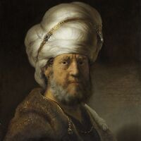
Mahmud bin Alsalam

Fatima bin Alsalam - bint Halbyurn


Grand Vizier
The Grand Vizier (Arboric: وزیر اعظم) is the head of government. At the time when the Emir was still in a coma, the Grand Vizier was also defacto the head of state. Since its awakening the role as Head of State is formally that of the Emir. The current and first Grand Vizier is Mustafa Asada, the Sawar of the Tassity Mansabdar.
The debate on the role and function of the Grand Vizier is still ongoing. The question remains unanswered as to whether the function is electable by direct or indirect election, or whether the Emir de Grand Vizier is appointed by nomination or not.
Majlis Al'imar
The Majlis Al'imar (Arboric: مجلس الإمارة) is the parliament of the Emirate. Elections to this parliament are scheduled for 1688 AN. Like many government institutions, the Majlis Al'imar will be based in Madinat al-Fath.
Culture
Stories
The Emirate of Arbor, as well as its predecessors, plays a role in the story series "The Micras Chessboard" and the "Tales of the Emira". These stories support or extend the description of the history of the Emirate.

